Thursday, December 23, 2010

Merry Christmas to all, and to all Dyker Lights

Even for the Grinchiest among us, the awesome spectacle of the Dyker Heights Christmas lights and displays in Brooklyn are a surefire holiday pick-me-up. So, as a Christmas gift to you, we offer an early PhotoFriday installment of the Dyker Lights.

No one really knows where the tradition began, but for decades this Brooklyn neighborhood of victorians, twin rowhouses, and 20th Century mini-palazzos is transformed into a winter wonderland of blinking lights and audio-animatronics. In lots of neighborhoods, people are content to hang a wreath or drape the railings with swags of evergreens. The blocks between 10th and 13th avenues and 81st and 85th streets in Dyker Heights take holiday decor to the next level. We're talking about 30' Santas, robotic polar bears, and light shows.

So, to you, dear reader, Happy Holidays from the Preservator. We'll see you in the new year.

84th Street is the heart of the action!

The Preservator has a weakness for light-up toy soldiers.

This house has the most elaborate, enormous, over-the-top displays of all. Too much is never enough.

Hop on the Polar Express!

Even the local fire company gets into the spirit.
All photos by @shrimpcracker

Thursday, November 25, 2010

Legend of Zelda, Lone Turkey in the Big City

This summer I was introduced to Battery Park's very own resident turkey, Zelda. I spotted her one afternoon, hanging out with some pigeons, allowing tourists to snap her photo. (As I did.) Evidently, Zelda has lived in Battery Park since 2003. As a single gal in the big city, she seems fine going about her business, making occasional sojourns to SoHo, Tribeca, the West Side Highway. She has also been profiled in the New York Times, NY Daily News, and NPR.

Yes, Zelda, you look good walking away too.
I think Zelda's probably in hiding for Thanksgiving. Or eating Chinese Food in protest. Still, I think she's a welcome reminder of nature in the concrete jungle. On this, most American of holidays, The Preservator wants to honor Zelda.  The humble American turkey was, after all, what Benjamin Franklin thought should be our national symbol, not the bald eagle. In a letter to his daughter, Franklin wrote that as compared to an eagle (a predator of ill moral character), "the Turkey is in comparison a much more respectable bird, and withal a true original native of America . . . He is besides, though a little vain & silly, a bird of courage, and would not hesitate to attack a grenadier of the British Guards who should presume to invade his farm yard with a red coat on."


Photos by The Preservator

Tuesday, November 23, 2010

A Glad Thanksgiving: Digitized

Among the good people, fortune, and places The Preservator will give thanks for this year, we wanted to take an especially nerdy moment to thank the good people of the world who work digitizing amazing collections, so that pieces of history can see the light of day on the internet. This is a big task and small armies of people help bring so many incredible resources to our fingertips.

I'm looking at you, PhillyHistory.org, the City Archives website, as well as your blog. I get lost in your geocoded image collections, culled from public agencies and the Athenaeum of Philadelphia, mining the city's history. 

And you, Library of Congress, where to even begin? I am thankful for the digitized HABS/HAER/HALS "Built In America" collection and, my personal favorite,  "By the People, For the People: Posters from the WPA 1936-1943 alone. That barely scratches the surface. 

This year, I've also loved falling down the rabbit hole of Flickr photostreams by powerhouse institutions like the Library of Congress, New York Public Library, U.S. National Archives, and DC Public Library, where public domain images have become even easier to find. 

On a more local note, Brooklyn Public Library, your Brooklynology blog makes me smile with images and strange tales of ephemera from your archives.

The Preservator will have a Glad Thanksgiving indeed. 

To see more of the NYPL's Vintage Thanksgiving Postcards, click here.


"A Glad Thanksgiving", Published by Whitney Valentine Co.
Vintage Holiday Postcard, NYPL
Image via New York Public Library, Mid-Manhattan Library / Picture Collection Digital ID: 1588314

Friday, November 19, 2010

Photo Friday: Blooming In The Noise

photo by The Preservator
Blooming, 1996. by Elizabeth Murray. Arts For Transit
59th and Lexington MTA station
 
The fantastical glass mosaic features lines poetry: from Gwendolyn Brooks is "Conduct your blooming in the noise and whip of the whirlwind," and from William Butler Yeats, "In dreams begin responsibility."

There's so much noise and whirlwind in the big city, bloom away, dear reader.

Thursday, November 18, 2010

Philadelphia Vacancy: Opportunities in Blight

27th and Girard Avenues. Photo via Flickr user MikeWebkist, Creative Commons License
What would you do with the thousands of vacant lots in Philadelphia? 

Like every rustbelt city in America, Philadelphia's population and economy has shrunk considerably since 1950. As the city has shrunk, vacant and abandoned properties are left dotting the city landscape, awaiting better days. A new report, "Vacant Land Management in Philadelphia: The Costs of the Current System and the Benefits of Reform," was released last week by the Redevelopment Authority of Philadelphia (RDA) and the Philadelphia Association of Community Development Corporations (PACDC), who are trying to grasp the depth of the vacancy problem and what to do about it.

The report estimates that of the 40,000 vacant parcels (identified using Water Department data for plots where water service has been turned off), 31,000 are held privately while 9,000 are public*. The result is serious tax delinquency that costs the city millions in lost revenue each year, and diminished property values of nearby parcels. While some of the properties identified as vacant still have structures on them, most are empty lots. Although these lots are pervasive, they are most concentrated in North and West Philadelphia.

By understanding the conditions surrounding property vacancies, Philadelphia hopes to create a more transparent, simple, and uniform process for the redevelopment of these properties. The report acknowledges that many of the problems and the solutions lie in the city's hands. Although Philadelphia could use its tax foreclosure powers to seize tax delinquent lots, it has been reticent to exercise this power. Now might be the time. Additionally, since no single city agency is responsible for acquisition, parcel assembly, disposition, or even planning for these properties. Mayor Nutter has, however, convened the different agencies responsible for pieces of the vacancy puzzle in order to develop a more coordinated approach.

In some neighborhoods, where the purchase prices of existing buildings exceed the cost of new construction, there is real potential for many vacant parcels to be developed into housing or some commercial use that will add value and vitality. In other neighborhoods where the problems of vacancy are greater, there is potential for some really interesting and different uses beyond housing, such as urban agriculture - a vibrant and important movement in Philly. The city will announce its ambitions for the creation of 500 acres of new open space next month, an initiative that will likely be aided by the extent of property vacancies. Overall, the goal is to reduce the number of long-term vacancies and to encourage transitioning these lots into productive use.

Diversified redevelopment of these vacant parcels would create jobs (construction and commercial enterprises), and generate badly needed revenue. Perhaps more importantly, it could help declining neighborhoods reverse course and stabilize.

*As an aside, the Preservator wonders, however, how many of the 9,000 publicly-owned parcels were razed by the Neighborhood Transformation Initiative under former Mayor John Street? This ambitious initiative (think creative destruction) sought to create development opportunities, but often resulted in blighted, vacant lots.

Related News:
"RDA Vacant Land Report Released" on PlanPhilly
"Growth Report: Reimagining Philly's Vacant Land" on The Griddle
"New Study Puts a Hefty Price on Philadelphia Blight" Jennifer Lin, Philadelphia Inquirer (check out the graphic with this article)

Friday, November 5, 2010

Photo Friday + Hot Links

Austin Limestone. It's everywhere and really suits the environment. Photo by Preservator.
 In the spirit of sharing, here's some interesting stuff from across the transom this week:

Scouting New York on the Smallest Plot of Land in New York City

Inga Saffon's Philadelphia Inquirer Architecture Critic on the new South Street Bridge design. It's not as beautiful as it could be, but there are bike lanes and chunks of it shouldn't be fall onto the expressway or the Schuylkill River anytime soon. We hope.

The New York Times reports on the Underbelly Project, a top secret art exhibition mounted in an abandoned subway station.

NYT City Room also reports on the removal of Roberta Brandes Gratz, whose books The Preservator has long enjoyed, from the NYC Landmarks Preservation Commission and will likely move toward the Mayor's advisory panel on sustainability. Her voice on the LPC was appreciated, and it will serve preservation well to have her in the room as PlaNYC is revised. Here's hoping preservation is better represented in the city's strategy for creating a more sustainable future. We're counting on you Roberta.

Thursday, November 4, 2010

Crumbling Coney

Coney Island's classic boardwalk. Photo by Preservator
In the ever-saddening annals of Coney Island, two bummers surfaced this week:

The New York Times reports that 9 boardwalk establishments are losing their leases. And one of The Preservator's favorite sites, Lost City, waxes nostalgic on Ruby's Closing. News like this confirms the fears that the homogenizaiton of Coney Island knows no end.

In other bad news, the Department of Parks and Recreation has proposed replacing part of the boardwalk with concrete. This ticked off Brooklyn Borough President Marty Markowitz, who trashed the idea in a letter to Parks Commish Adrian Benape. The NY Daily News's coverage (here) said that Parks was trying to comply with the city's policy of reducing use of tropical hardwoods. Surely, Marty says, there's another sustainable option that keeps the boardwalk real. There's a part of me that thinks even if everything else changes at Coney Island, at least there's the boardwalk and the beach. The BOARDwalk (not concrete sidewalk) is part of what makes the place what it is, and speaks to its history. To ditch it is remarkably disrespectful and uncreative.

Wednesday, November 3, 2010

Modernistic Austin

The Preservator has, dear reader, been on a brief hiatus. It wasn't you, it was we. In part, The Preservator has been on the road. One recent stop was at the National Trust for Historic Preservation Conference in Austin, Texas.

In Austin, The Preservator was lucky enough to take a a walking tour of downtown's Art Deco buildings. Evidently, Art Deco came late and stayed late in Texas, leaving behind a rich mixture of public and private buildings in the Texas Hill Country. In Austin, here's some of what we saw.


At the time these buildings were constructed, they weren't called Art Deco, but simply "Modernistic." The Depression-era building boom that led to the construction of these buildings also helped create a more modern image of Texas and its cities.

Our tour was led by the wonderful historian David Bush from the Greater Houston Preservation Alliance. Along with his colleague Jim Parsons, Bush wrote Hill Country Deco, which was the impetus for the tour.

Friday, October 8, 2010

Photo Friday: Carriage Barn

Photo by Preservator
Sunday, October 3, 2010. Morning at the Coach Barn at Shelburne Farms, built 1902.

Thursday, October 7, 2010

Gov. Christie Derails ARC Tunnel

New Jersey Governor Chris Christie is making The Preservator’s blood boil. Today Gov. Christie announced that he is pulling New Jersey’s funding for the ARC (aka Access to the Region's Core) Transit Tunnel under the Hudson River.  Gov. Christie put a moratorium on the construction of new tunnels for commuter rail lines under the Hudson River, citing concerns about the project’s budget.  It has been widely reported that Gov. Christie was expected to pull state funding from the project. In doing so, Gov. Christie has made a decision that would adversely affect the entire Northeast Megaregion by choking commuter rail travel even as ridership increases.
Proposed map of ARC Tunnel project. Image via arctunnel.com, by NJ Transit and the Port Authority of NY and NJ

Despite this announcement today, Transportation Nation reports that Transportation Secretary Ray LaHood and Gov. Christie intend to meet tomorrow to discuss alternatives so that the ARC Tunnel project may continue.

Right now Amtrak and New Jersey Transit share the two century-old rail tunnels between New Jersey and Midtown Manhattan. These tunnels are at capacity; meanwhile ridership has more than quadrupled since 1984, and has increased 150% in the last 10 years.  The ARC tunnel would double the existing commuter rail capacity between NJ and NY, carrying an additional 100,000 passengers daily.

On the Manhattan end, this tunnel is a component of the intricate planned expansion of New York Penn Station and the restoration of the old Farley Post Office, set to become the new Moynihan Station. After years in the planning, the ARC tunnel construction phase began in 2009 and tunneling began this year. Of the $8.7 billion budget, the Port Authority of NY and NJ and the Federal Transportation Authority are each putting $3 billion toward the project, and the State of New Jersey had pledged about $2.7 billion to the project. According to Gov. Christie's estimates the actual project budget is anticipated to top $11 billion.

Gov. Christie’s excuse for stalling and canceling the project is that New Jersey would be on the hook for cost overruns. He says that because New Jersey is broke, the taxpayers cannot afford any additional costs. And, by the way, Gov. Christie reportedly wants to use the $2.7 billion committed to ARC to plug the impending bankruptcy of the state’s Transportation Trust Fund, which is used to maintain the state’s roads and rails. At best, transit advocates say, this funding will only solve the state’s transportation funding for a few years.

If U.S. Senator Frank Lautenberg (D-NJ) has his way, New Jersey will have to reimburse the $300 million (plus interest and penalties) of federal dollars already put toward the project. Essentially, the state would be breaking its commitment to the project, in exchange for which New Jersey received Federal funding. If that weren’t enough, Lautenberg asked the Port Authority this week to commit to covering any overruns.

Gov. Christie’s decision is outrageous. While it’s true that New Jersey is struggling financially, the tunnel project is anticipated to turn a profit for the state after it is built. A report by the Regional Plan Association (RPA) this summer projected significant property value increases (and therefore property tax revenue) for homes near rail stations in New York and New Jersey.  Additionally, the same RPA report notes that because the ARC tunnel would shorten commute times, the number of commuters will increase.

The Preservator takes the long view on just about everything. When we’re forward looking, it’s to a deep future, not the next 5-10 years. Times may be hard today, but New Jersey cannot and should not make decisions out of political expedience at the expense of real long term gains. 

Many transportation advocates have suggested that New Jersey should raise its absurdly low gas tax, which has remained stable for decades and contributes to the state’s low prices at the pump. Raising the gas tax may even push more commuters out of the driver’s seat and into the state’s rail system.

In killing this project Gov. Christie would commit one of the worst decisions for the entire region of the century. America can no longer be in the business of building fossil-fuel dependent transportation. The ARC tunnel project has been 20 years in the making and is the precise sort of project that the America of the 21st Century needs. We need more efficient and sustainable ways of moving regional populations to work. Any transportation planner will tell you that you cannot build your way out of a traffic problem by increasing road capacity. It simply doesn’t work. Our nation’s rail system (freight, Amtrak, regional rail) has been woefully underfunded and the Obama administration is working hard on reversing that trend.  (It helps that Vice President Biden was an Amtrak commuter as a Senator.)

You can thank Gov. Christie for keeping the Northeast Megaregion trapped in the 20th Century, with punishing commutes on aging infrastructure. You can thank him for filling New Jersey’s potholes and robbing the region’s future to do so.

Friday, October 1, 2010

Photo Friday: Empire Stores


The Empire Stores c. 1869. 1885.  53-83 Water Street, Fulton Ferry Historic District, Brooklyn. September 13, 2010. 10:52am

Wednesday, September 29, 2010

Stars Shine at Eldridge Street Synagogue

An early design illustration of the new window stained glass window design. Photo illustration by Wiss, Janney, Elstner Associates
 On October 10th The Museum at Eldridge Street (aka Eldridge Street Synagogue) will celebrate the installation of a magnificent new stained glass window designed by Kiki Smith and Deborah Gans, created by The Gil Studio

The new east window was commissioned to replace a glass-block window installed in the 1940s after the original was damaged and ultimately removed.  The monumental round window will occupy the focal point of the sanctuary. While there was no documentation of the original window's design, the new window design is a sensitive, yet modern, intervention into this National Historic Landmark.

On Monday, Eyewitness News aired this bit about constructing the window:

According to the Museum's website, the project has been substantially supported by the likes of  American Express, The David Berg Foundation, The Richard H. Driehaus Foundation, The David Geffen Foundation, and the City of New York.

For those still curious, here's a bit from The New Yorker written by Paul Goldberger about the window project. "She Does Windows"

For those even more curious, The Museum at Eldridge Street will host a conversation with Kiki Smith and Deborah Gans on Wednesday, November 17th at 6:30pm. Tickets are $15, $12 for students and seniors.

Friday, September 24, 2010

Photo Friday: Feast of San Gennaro

The Feast of San Gennaro along Mulberry Street, September 21, 2010 5:29pm. Photo by The Preservator.

This week the 85th Feast of San Gennaro is being celebrated along the length of Mott and Mulberry streets in New York City's Little Italy (Chinatown? Five Points? Two Bridges?).  The feast honors the martyrdom of San Gennaro, the Patron Saint of Naples, and has been held in Little Italy since 1926, centered around the National Shrine to San Gennaro at the Church of Most Precious Blood (just around the corner at 113 Baxter Street). The feast runs through Sunday, September 26th.  

For a full and colorful explanation of the Feast, check out this two part series from The Bowery Boys in 2007.
Part 1: Blood and Sideshows
Part 2: Most Precious Blood

Monday, September 20, 2010

Choose Your Scaffolding Adventure: urbancanvas Design Competition

One of the eight urbancanvas finalists: "My Urban Sky," by Jen Magathan
New York City's urbancanvas Design Competition is aiming to dress up dress up the otherwise bland fixtures of  construction sites - sidewalk sheds, construction fencing, scaffolding and protective netting - in a temporary artsy new skin. The contest is being held by the departments of Buildings and Cultural Affairs in an effort to create a positive, attractive, and interesting additions to New York City's urban environment while buildings are under construction. The hope is to enhance the public realm with artwork that is broadly accessible, created in a flexible system that can be adapted to different scale buildings in different settings.

Of the 700-plus artists who registered for the competition, eight finalists were selected by a jury this summer. Today the finalists were announced and are currently up for public vote until October 1. The four artists that get the most votes will not only see their designs beautifying New York City's construction sites but will receive $7500 from the Rockefeller Brothers Foundation. And, of course, we the people get something to enliven the otherwise unattractive city-owned buildings under construction.

View and vote for the designs here.

Friday, September 17, 2010

Old Fulton Street


 Three historic buildings on Brooklyn's Old Fulton Street are facing the possibility of demolition. Numbers 11, 13 and 15 Old Fulton Street were built in the late 1830s when this was a busy commercial district around the Fulton Ferry landing at the river's edge. They predate the Brooklyn Bridge by nearly 50 years.

The three properties have been under vacate orders for months because their rear wall is in danger of collapse.
One reason the buildings are unstable is because they are built on poor fill, and the ground has settled over time. Another reason appears to be owner neglect. The good news: the owners recently removed tons of debris to lighten the loads within the buildings, and are now in negotiations with the city to avoid demolition.
The Fulton Ferry Historic District was designated by the Landmarks Preservation Commission in 1977. It's a small district and with these three buildings lost, it would certainly lose some integrity. With the increased development of DUMBO and Brooklyn Bridge Park this area is seeing much more attention and it would be great to see these buildings restored. The neglect these buildings have suffered is a shame. It would be sadder still to lose them altogether.

 Photo via National Park Service
Above you can see what the north side of Old Fulton Street looked like in 1974 when the Fulton Ferry National Register district was designated. The buildings at 11-15 Old Fulton are to the right of the gap in the buildings.

For more info:
Brooklyn Paper, "Historic Building Could Be Destroyed on Old Fulton Street"
DumboNYC.Com "Update on 11-15 Old Fulton Street Demolition"
Fulton Ferry Landing Association "11-15 Old Fulton Update"

All color photos by The Preservator.

Friday, September 10, 2010

Photo Friday: The Sphere, Battery Park

"The Sphere", Battery Park, NYC. September 10, 2010. Photo by The Preservator.
The plaque at "The Sphere" reads as follows:

For three decades, this sculpture stood in the plaza of the World Trade Center. Entitled "The Sphere", it was conceived by artist Fritz Koenig as a symbol of world peace. It was damaged during the tragic events of September 11, 2001, but endures as an icon of hope and the indestructible spirit of this country. The Sphere was placed here on March 11, 2002 as a temporary memorial to all who lost their lives in the terrorist attacks at the World Trade Center. This eternal flame was ignited on September 11, 2002 in honor of all those that were lost. Their spirit and sacrifice will never be forgotten.
 
This week, "The Sphere" is surrounded  by flags that say "Flag of Honor" or "Flag of Heroes." The Honor flag has the names of first responders who lost their lives and the Heroes flag has the names of everyone who died in the four attacks on September 11th. 

The Tree of Liberty: Federal Hall


Tucked into Lower Manhattan's intimate colonial streets sits a quiet landmark, hidden in plain sight. Federal Hall may be overshadowed by its saucier neighbor, the New York Stock Exchange, but its stately form and its cultural significance make it a site worth visiting.

When New York was the nation's capitol city, Lower Manhattan saw a lot of action. The intersection of Wall, Broad, and Nassau streets is one of the most significant locations in all of the city. Here, outside of the original Federal Hall, George Washington gave his first inaugural address. On this site Congress debated and ratified the Bill of Rights, and the judiciary held the first trial over freedom of the press. After the national capital relocated to Philadelphia in 1790, the Federal Hall became New York's City Hall again. In 1812 the original building was demolished.

The Federal Hall we see today is a handsome classical revival building designed by Ithiel Town and Andrew Jackson Davis, and built in 1842 as a custom house. Town & Davis chose monumental Doric columns outside as a nod to the ideals of Greek democracy. The interior's main domed chamber, designed by John Frazee, borrows from the Roman Pantheon. After the Customs House opened at Bowling Green, the building became the sub-treasury, housing millions of gold and silver in its vaults. In 1939 the building was designated a National Historic Site, more recently it was designated an interior and exterior city landmark.


Federal Hall National Memorial is open to the public, managed by the National Park Service. Admission is free and it's open 9-5. A visit on any given day will reveal tourists snapping pictures, New Yorkers noshing on the steps below George Washington's statue.

The cool classical restraint of the Federal Hall's exterior communicates strength and permanence, the interior conveys power yet approachability. How American. After the attacks on September 11, 2001 Federal Hall's existing structural issues became pressing emergencies. The building was reinforced, restored, and reopened in 2006. Federal Hall is a beautiful expression of democratic ideals, and despite deeply unsettling days, it stands resolute.

All Photos by The Preservator.

Friday, September 3, 2010

Photo Friday: Brooklyn Botanic Garden

Fragrance Garden Gate at the Brooklyn Botanic Garden. 
August 29, 2010. Photo by Shrimpcracker.

The Fragrance Garden at the Brooklyn Botanic Garden was created in the 1950s and is a garden designed for the seeing-impared. The signage is also in braille and the plantings are selected to heighten the other senses: they are meant to be touched and smelled.  

Happy Labor Day weekend, all.

Friday, August 27, 2010

Photo Friday: The Beekman Tower

Continuing on this week's skyline theme, here's Frank Ghery's Beekman Tower as seen from City Hall Park, behind the late-nineteenth century buildings on Park Row. At left is 41 Park Row, which is the former New York Times building, and at right is the Potter Building at 38 Park Row.
August 26, 2010. Photo by Preservator.


And while we're on the subject, here's a neat interview with the architecture critic, Paul Goldberger, from a conversation on WNYC last week. I particularly enjoy the way Goldberger addressed the complaint that the Beekman Tower obscures views of the historic Woolworth Building.

He said, "I don't think it will take away from the Woolworth at all. I think it will, in fact, communicate nicely with the Woolworth. You have two different generations talking to each other, which is good. And it's not right up against the Woolworth; it's actually a little distance away, so they can really communicate with each other, but also stand alone in a certain way."

Tuesday, August 24, 2010

Skyline Swordfight: 15 Penn Plaza and the Empire State Building

Is the Empire State Building so spectacularly special that it warrants a 17-block buffer from other skyscrapers? Its owners, Anthony and Peter Malkin, think so.

The Malkins are in a twist about a proposed tower at 15 Penn Plaza, being developed by Vornado Realty Trust and designed by Pelli Clarke Pelli. This proposed tower would be barely shorter than the Empire State Building, though it would have a bulkier massing. The buildings would be about 900 feet apart.  Because of the size and proximity, opponents of the new 15 Penn Plaza foresee the end of largely-unobstructed views of the Empire State Building from many places in New York. The Malkins are hoping to see the proposed tower reduced in stature, if not outright rejected.
Rendering of the Empire State Building and the possible 15 Penn Plaza. via Architects Newspaper Blog here.

The Empire State Building is one of the most iconic buildings in New York, and one of the best-known and loved in America. No dispute there. It has also stood above its surroundings with little competition for the last 79 years.  The Empire State Building is a designated city landmark and a National Historic Landmark. But just because it's a landmark, and just because so many people like it or can see the way it lights up at night doesn't mean nothing similarly tall can be built nearby. Frankly, at nearly 80 years old, it is impressive that the Empire State Building has had so little competition in the skyline.

The planned tower at 15 Penn Plaza was approved by the Department of City Planning earlier this summer. City Planning also granted variances allowing the building to be constructed at a height more than double what the site's  zoning permits as-of-right. City Planning's logic is that there should be high-density development around Penn Station. (There's more of this to come as Moynihan Station materializes. Stay tuned.) It's got to also help that Vornado is promising a chunk of change for transit-related investments at the site as well. (Which, is all the Municipal Arts Society chose to offer testimony on before City Planning. Fascinating.)

Yesterday the City Council Subcommittee on Zoning and Franchises heard testimony about the proposed tower.  In all likelihood, the City Council will approve the proposed tower.

There's no special zoning overlay for the Empire State Building restricting height within a certain radius. Views of the Empire State Building's aren't exactly protected by its landmark status. And, even though the proposed new building is not particularly attractive, it's a good idea to encourage high density around the Moynihan-transit-hub-to-be.

Moreover, New York's is a changing skyline. It should stay that way.

Related Linkage:
"More Shots Fired in the Battle of the Midtown Skyline," Curbed
"Save Our Skyline, Begs Empire State Building," Architects Newspaper Blog
"A Fight on New York's Skyline" The New York Times

Friday, August 20, 2010

Photo Friday: Cornice and Corbels

Cooperstown, NY. August 13, 2010.
Even on vacation this is how The Preservator's photos turn out.
Photo by Preservator.

Thursday, August 19, 2010

Update Bonanza: Coney Island is Historic and Being Demolished / Community Garden Advocates Break Out the Big Guns

Busy times over here at Preservator HQ with updates regarding some topics recently covered on these pages. And you thought summer was a slow news season!


Coney Island:
Last week Coney Island's historic resources received a nod for their importance, as well as demolition permits.

Coney Island's Boardwalk is eligible for listing in the State and National Registers of Historic Places. Photo by Preservator.
On the upside, the staff from the New York State Department of Parks, Recreation, and Historic Preservation trekked out to Coney Island and found that its historic resources - including the boardwalk (!) - are eligible for listing in the State and National Registers of Historic Places. Even though this determination provides no protections that some form of designation would, it's validation of the significance these resources.

Save Coney Island posted the August 12th Determination of Eligibility on their website. In it, the state wrote: "While much of historic Coney Island has been lost through the years due to neglect, fire, or urban renewal beginning in the Moses era, the core of surviving buildings, structures, objects, and landscape features that have remained are valuable cultural assets worthy of recognition and consideration in preservation planning." It also called the amusement district "nationally significant...as the birthplace of the modern American amusement industry."

Almost immediately Thor Equities pulled two demolition permits.
Shore Hotel, Coney Island, Photo by Preservator.
Wrecking has begun at the Shore Hotel and the Bank of Coney Island. Also on the chopping block are the Grashorn Building and Henderson's Music Hall, where Thor is so eager they're even working without a demolition permit.

Henderon's Music Hall, Coney Island, Photo by Preservator.
Careful observers will note that the state's proposed historic district boundaries are much larger than those put forward by advocates. The state, wisely, included the boardwalk. Huzzah!


View Coney Island - DoE boundaries in a larger map

 Note: The blue line is the state boundary for eligible resources, and the pink is the initially the proposed boundary. 

Previously on Preservator: Keep Coney Island Real


Community Gardens:Last week's public hearing about the contentious new rules for New York City's community gardens was apparently well attended and got lots of press. A good list of links is on the New York City Community Garden Coalition's (NYCCGC) website.
City Council Speaker Christine C. Quinn speaking with people waiting to testify at the August 10th public hearing on new rules for community gardens. Photo by Matthew McDermott, Flickr / Creative Commons License.
City Council Speaker Christine Quinn and parks committee chairwoman Melissa Mark-Viverito made the case for the city's community gardens, in a New York Times op-ed yesterday, titled "Constant Gardens for New York." They call for community gardens to become more stable and long-lasting features of New York's urban fabric. They advocate for more permanent and protective rules, a more straightforward process for license renewal and site turnover, and conditions for city eviction. The Council Members are on the mark.

NYCCGC also links to the testimony from former Assistant Attorney General, Christopher Amato, who was the lead lawyer for New York State in 2002 during the case which resulted in the current garden agreement that provides more protections than the current proposed rules. at the August 10th hearing on the new proposed rules. If you're into it, read the 7 page letter. It's a barnburner.

Amato contends that the new rules weaken the protections for community gardens, and violate the spirit of the 2002 agreement. He, more interestingly, makes the case that these gardens are parks by common use (think common law), even if they're not treated the same as other parks run by the NYC Department of Parks and Recreation. Treehugger breaks it down here. While Amato offered his testimony as a private citizen, he happens to be the Assistant Commissioner in the Department of Environmental Conservation Office of Natural Resources.

Previously on Preservator: Machines in the Garden

Tuesday, August 17, 2010

Two Staten Island Majestic Maritime Beauties at Auction

West Bank Lighthouse, Ambrose Channel / Lower NY Bay
Ever dreamed of living along a rugged oceanic coast, left peacefully removed from neighbors but for the gulls, yet still able to come to the big city when you wish? Are you in the market for a retreat complete with round rooms and majestic 360-degree views of New York Harbor? The U.S. General Services Administration has two lighthouses that might just suit your fantasy.

The Staten Island Advance reported yesterday that the U.S. General Services Administration (GSA), the federal government's property ownership/management agency, has put two surplus lighthouses on Staten Island up for auction. Old Orchard Shoal Lighthouse (top) and West Bank Lighthouse (below) are both open for bidding.  The opening bid, which enables a tour on September 1, is $20,000.

Old Orchard Shoal Lighthouse, Gedney Channel / Lower NY Bay


Surplus lighthouses pose a special problem for the federal government - they're expensive to maintain and operate, and many are landmarked.  If a surplus property listed (or eligible for listing) in the National Register of Historic Places, as both lighthouses are, the National Park Service offers these properties to state, county or local governments at no cost through the Historic Surplus Property Program. The objective is to put these buildings into productive public use, and are often leased to local nonprofit groups, while protecting their historic integrity.  If there are no takers, the property can be auctioned by the General Services Administration, which is what's happening with the Old Orchard Shoal and West Bank Lights.

Old Orchard Shoal Light, was built of cast iron and first lit in 1893 to protect ships from hitting the rocky shoals of Lower New York Bay.  Below its octagonal lantern is an observation room, and the keepers's quarters are roughly 1000 square feet.  The West Bank, or Range Front, Light was built on a man-made island and was first lit in 1901, and boasts a 100 foot breakwater.  Both properties are only accessible by boat. (How exclusive!)

Lest you fret about sailors busting up along the rocky shores of Staten Island, know that the lights are automated and will remain operational. And if you're the new owners of one of these lights, the U.S. Coast Guard will still come by to do maintenance (think of them as the super for the light).

Bid info here:
GSA Old Orchard Shoal Light auction website
GSA West Bank Light auction website

Both images are U.S. Coast Guard Photos found here.

Friday, August 6, 2010

Photo Friday: International Telephone and Telegraph Corporation

I walk past this mosaic frequently in Lower Manhattan. The bolt of electricity between the figure's fingers reminds me of this William Blake quote:  "My fingers emit sparks of fire with expectation of my future labors." (Do you think this is how the Internet would like to be depicted?)

International Telephone and Telegraph Corporation, 75 Broad Street, Manhattan
Photo by Preservator; all rights reserved

Machines in the Garden

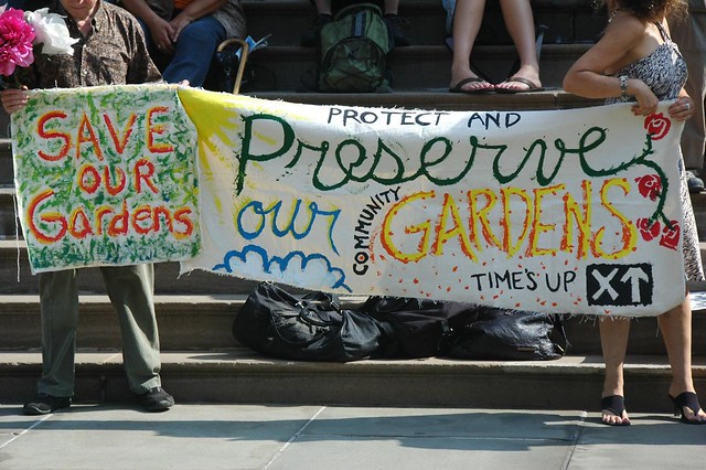
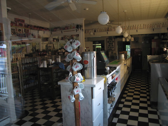
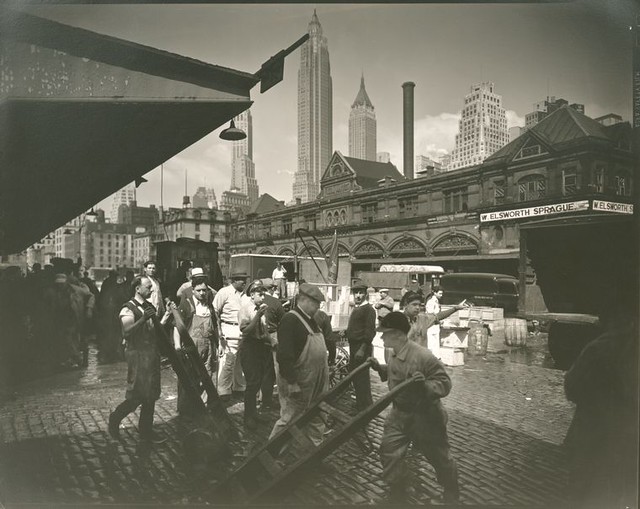
Protest at City Hall 8/4/10 in opposition to new rules for Community Gardens. Photo via Flickr by FlatbushGardener


A greener, healthier city is not one that bulldozes and develops its Community Gardens. But, there is a machine quietly revving in the garden.

New York City’s departments of Parks & Recreation and Housing Preservation & Development have proposed new rules for Community Gardens, which advocates and gardeners say would strip back hard-won protections currently in place. These new rules would allow for the sale and development of any garden citywide not owned by a community land trust or by a city agency.

Before we dive into the disagreement at hand, a little background. 

Recent generations of community gardeners, particularly those in low-wealth neighborhoods, worked hard to create these gardens by reclaiming parcels that were otherwise eyesores and safety hazards: These abandoned lots were overgrown at best and at worst they were illegal dumps, squatters camps, drug dealing spots, etc. Out of the ashes of arson and dereliction grew not only gardens, but community. As neighbors came out to work together, they warded off unwanted activity and created something powerful and productive out of otherwise unwanted spaces. Today’s community gardens still serve these functions and more. Beyond the reclamation and reinvention of these places are really important moves toward creating more resilient and sustainable cities. Community gardens help green cities – filtering air and reducing runoff, beautifying blocks – they help feed urbanites – every little bit counts – and they encourage civic engagement.

In New York, as elsewhere, many community gardens began as informal, ad-hoc spaces with no legal relationship to the land being cultivated. Over time many sites, like those in the East Village, began to face intense development pressure. Still, as some gardens were lost, others became more institutionalized features even as real estate pressures mounted. After the "Garden Wars" of Giuliani's administration, New York's community gardens gained greater security in the form of land transfers to community land trusts or to the city. In 2002, an agreement brokered between the City and then Attorney General Spitzer – brought yet greater protections for some 500 gardens while 150 others were slated for development.  Many gardens worked with the Parks Department's GreenThumb program, which provides support (through largely federal funding sources) for community-managed spaces. 

Because the 2002 agreement sunsets in September, the city has proposed new rules. Advocates like the New York City Community Garden Coalition, say these rules erode protections that were afforded gardens by the old agreement, and in so doing expose gardens citywide to development at the discretion of the city. The draft language of the proposed new rules (Parks rules here) (HPD rules here) treats every garden as a building site. The new rules eliminate the process by which gardens can be transferred into city ownership, meaning that if a garden site is not owned by a land trust or the city already, they effectively are at the mercy of the city’s goodwill.

This is about the gardens being devalued at the expense of potential development. It's about devaluing community-managed spaces and civic participation in something productive and beautifying.  There are provisions that would offer a new lot for the garden to move to, if available, but this misses the point. Gardening takes time. Offering an “as is” lot isn’t an equal trade for a community garden with mature plantings and amended soils. They’re not the same and accepting an alternate site might just mean starting from scratch. Again.

New Yorkers deserve a cleaner, greener, healthier city. Community gardens help fulfill this vital, very 21st Century goal. New York City may have the most intense development environment in the nation, and its policy goals for making the city more sustainable are a model for many other cities. These policy objectives are not in line with the new rules for community gardens. New York City will never be able to produce all of the food necessary to feed itself, but community gardens can help. Better still, they help provide really healthy and affordable food options in low-wealth “food desert” neighborhoods, acting as food banks or donating produce to pantries.

Even as community gardens have waiting lists for plot space, and urban agriculture is a renewed and growing trend, the city fails to recognize the full value of these productive plots, as food sources, community development tools, as green breaks in the concrete jungle. Parks Commissioner Adrian Benape was quoted in yesterday’s AM New York saying, “There is not a universal love of gardens.”  The piece also suggested that he doesn’t believe that the gardens can be made "permanent" because nothing in the city is really forever. Still, he said, “There are no bulldozers being warmed up.” That may only be due to the weakened development climate.

There’s some meaningful research underway that should add good data and policy recommendations for community gardens and urban farms.  Among these are the garden mapping project that Farming Concrete has underway and the Design Trust for Public Space’s Five Borough Farm project. Hopefully these project will also help illuminate the myriad values of the city's gardens.

Community Gardens might not make the city or developers much in the way of money, but wouldn’t New York City be poorer without them?

On Wednesday, August 4th gardeners and supporters rallied at City Hall wielding beets and chard, asking the city leadership to provide greater protections for the city's community gardens.  There is a public hearing on August 10th about the proposed rules. This is your chance to make your voice heard on this issue. Write a letter; call 311; even sign up to testify. Check out NYCCGC’s website for all of the details.

Want to find a garden? Search for a garden via Oasis here.

Friday, July 30, 2010

Photo Friday: Streetview Circa 1889

Oh ninteenth century, how the proud drawings of your creations rule. As does your attention to detail. I submit to you, on this Photo Friday: a visual tour of Broadway in NYC circa 1889. The Mail & Express newspaper published this block-by-block pictorial directory of buildings and businesses along Broadway from Bowling Green to Columbus Circle. It's sort of like a visual yellow pages and map in one. (Come! Cruise Broadway! What a civilzed environment to shop and do business!)


Created with Admarket's flickrSLiDR.

These images can be browsed in the New York Public Library's Digital Gallery, and have been made available through their awesome flickr page. I highly recommend clicking on a few to check the buildings out in higher resolution. Here's one I like showing Trinity Church.

Tuesday, July 27, 2010

All Things Must Pass: Papa's, Lake Luzerne, NY

Papa's is the ice cream parlor of my dreams.

Summer visits to Papa's Ice Cream Parlor in Lake Luzerne, NY are among my fondest memories of living upstate.  Lake Luzerne is a village in the Adirondack foothills where the Hudson and Sacandaga rivers meet. Along the Hudson, before the rivers meet, just upriver from a small falls, there is a house with a big porch overlooking the Hudson. That's Papa's.

Papa's was an old school ice cream parlor, even though it was only established in the 1970s. Teenage waitresses working their summer jobs would wear tees saying "Papa's Girl," serving ice cream and soda fountain treats in glass dishes. At Papa's you could sit on the shady dining porch overlooking the river, chow down on a barbecue chicken sandwich, and then contemplate the most important choice of the day: what to eat for dessert. I always chose fruit flavors. My dessert of choice was a brownie sundae with cherry ice cream. Heaven on earth.

Papa's was only open in summer, and each year I dream of visiting. I had my heart set on actually getting to Papa's this summer and I was crestfallen to learn that it is no longer open. Though, I suppose, I'm not totally surprised. In 2002, the original Papa's caught fire and the Gardner family rebuilt their restaurant on an adjacent lot. In 2008 Papa's was sold. Now the building and business are for sale again. Here's hoping someone brings Papa's back to life.

One of the nicest days I ever spent with my friend PD was one Fourth of July more than a decade ago, punctuated by my first trip to Papa's. We walked down to the river and watched boys jumping (terrifyingly) off a bridge into the deep water below the falls. We ate lunch on the porch and gorged ourselves on ice cream. We went back to Saratoga Springs and watched fireworks.
Another piece of fine Americana, gone by the wayside.

The pencil cup on my desk is a mug from Papa's, a reminder of the sweet things in life.


Photos via Flickr user, warsze

Friday, July 16, 2010

Photo Friday: Berenice Abbott

In 1935 photographer Berenice Abbott was hired by the Federal Art Project to work on their "Changing New York" project.  The results, in stunning photographic form, are potent images of everyday life in New York City from 1935-1938. We owe her, and the WPA programs a debt of gratitude for this extraordinary record. Below are a few select favorites, but more can be viewed through the New York Public Library's Digital collection here and through their Flickr account here.

For your viewing pleasure:
 Court of first model tenement house in New York, 72nd Street and First Avenue, Manhattan.  (March 16, 1936)  
New York Public Library


Milk wagon and old houses, Grove Street, No. 4-10, Manhattan. (June 18, 1936)
New York Public Library
 
Warehouse, Water and Dock Streets, Brooklyn. (May 22, 1936)New York Public Library

Radio Row, Cortlandt Street, Manhattan. (April 08, 1936)
New York Public Library
Fulton Fish Market, Manhattan. (June 18, 1936)
New York Public Library

Tuesday, July 13, 2010

Historic Aerial Photographs of NYC

The good people behind NYCity Map have brought a smile to the Preservator's world today. Last week NYCity map added to its set of aerial photographs of New York City. According to NYCity Map Blog version 7.0 now has 1951 Aerial images obtained from the Department of Records. This means that another fantastic data tool is at our fingertips as we research sites through time: from 1924, to 1951, to 1996, to 2006, up to 2008.
Historic maps are great resources for preservationists, planners and historians alike, but aerial photographs can be even more potent. Maps are drawn and there can be an element of mystery (particularly with old maps), but photos tell it like it is. Now NYC researchers have even more historic aerial photos to use thanks to NYCity Map. Aerial photos are powerful tools that enable us to better understand a site's context and the trajectory of neighborhood history.

As previously posted here, the 1924 aerial photos were taken by Arthur Tuttle for the city's chief engineer. They are an extremely important set of photos that enable urban historians and researchers to understand neighborhood, and indeed citywide change. (You can also view this set through the New York Public Library's Digital Gallery here.) Prior to the addition of the 1951 aerial, there was a jump between 1924 and 1996. That is a huge span of time in which the city changed radically. (And yet, in so many interesting ways, stayed the same.)

Consider this example of downtown Brooklyn:
In a 1924 aerial, below,  you can see the Manhattan (center left) and Brooklyn (left) bridge approaches complete with a maze of train tracks. Pieces of the Navy Yard are also at right. Commodore Barry Park (bottom right) is a more formally designed square than its current configuration.

Now compare the above with the aerial from 1951 below. Same area, but look at what change 25 years can bring. Cadman Plaza replaces a maze of traintracks off the Brooklyn Bridge. The Farragut Housing towers have sprung up from once-dense and small-scale blocks.  Also, Commodore Barry park is now the ball fields we see today.

Pretty neat, right? Browse around and see what you find.

Monday, July 12, 2010

Preserved Fish?

When I walked past the New York City Marble Cemetery on East 2nd Street in Manhattan’s East Village I dutifully read the plaque explaining the significance of this nonsectarian cemetery’s history.  Listed among "other notables interred here" is "Preserved Fish, a prominent merchant..." Preserved Fish? I read it twice.


Who names their child Preserved Fish? Apparently men named Preserved Fish. According to a May 2000 NY Times piece, he was the THIRD consecutive Preserved Fish, of a Rhode Island Quaker clan.  His first name was pronounced with three syllables: Go ahead and say it. Pre-ser-ved. It means “preserved from sin” or “preserved in grace". Natch.  This Preserved Fish was a wealthy banker and merchant who made his money in Whale Oil. 

Bonus Fact: This is the same Fish clan that gave New York its Governor, Hamilton Fish.

To see it for yourself, the New York City Marble Cemetery's gates will be open July 25 from 3-5pm. The gates are rarely open. If you go, you should make sure to pop around the corner to the totally-unrelated-though-similarly-named New York Marble Cemetery, which is only open once a month. This month, it will also be open July 25 from noon-4pm. Good timing.

All photos by Preservator, all rights reserved.