Tuesday, July 13, 2010

Historic Aerial Photographs of NYC

The good people behind NYCity Map have brought a smile to the Preservator's world today. Last week NYCity map added to its set of aerial photographs of New York City. According to NYCity Map Blog version 7.0 now has 1951 Aerial images obtained from the Department of Records. This means that another fantastic data tool is at our fingertips as we research sites through time: from 1924, to 1951, to 1996, to 2006, up to 2008.
Historic maps are great resources for preservationists, planners and historians alike, but aerial photographs can be even more potent. Maps are drawn and there can be an element of mystery (particularly with old maps), but photos tell it like it is. Now NYC researchers have even more historic aerial photos to use thanks to NYCity Map. Aerial photos are powerful tools that enable us to better understand a site's context and the trajectory of neighborhood history.

As previously posted here, the 1924 aerial photos were taken by Arthur Tuttle for the city's chief engineer. They are an extremely important set of photos that enable urban historians and researchers to understand neighborhood, and indeed citywide change. (You can also view this set through the New York Public Library's Digital Gallery here.) Prior to the addition of the 1951 aerial, there was a jump between 1924 and 1996. That is a huge span of time in which the city changed radically. (And yet, in so many interesting ways, stayed the same.)

Consider this example of downtown Brooklyn:
In a 1924 aerial, below,  you can see the Manhattan (center left) and Brooklyn (left) bridge approaches complete with a maze of train tracks. Pieces of the Navy Yard are also at right. Commodore Barry Park (bottom right) is a more formally designed square than its current configuration.

Now compare the above with the aerial from 1951 below. Same area, but look at what change 25 years can bring. Cadman Plaza replaces a maze of traintracks off the Brooklyn Bridge. The Farragut Housing towers have sprung up from once-dense and small-scale blocks.  Also, Commodore Barry park is now the ball fields we see today.

Pretty neat, right? Browse around and see what you find.

Monday, July 12, 2010

Preserved Fish?

When I walked past the New York City Marble Cemetery on East 2nd Street in Manhattan’s East Village I dutifully read the plaque explaining the significance of this nonsectarian cemetery’s history.  Listed among "other notables interred here" is "Preserved Fish, a prominent merchant..." Preserved Fish? I read it twice.


Who names their child Preserved Fish? Apparently men named Preserved Fish. According to a May 2000 NY Times piece, he was the THIRD consecutive Preserved Fish, of a Rhode Island Quaker clan.  His first name was pronounced with three syllables: Go ahead and say it. Pre-ser-ved. It means “preserved from sin” or “preserved in grace". Natch.  This Preserved Fish was a wealthy banker and merchant who made his money in Whale Oil. 

Bonus Fact: This is the same Fish clan that gave New York its Governor, Hamilton Fish.

To see it for yourself, the New York City Marble Cemetery's gates will be open July 25 from 3-5pm. The gates are rarely open. If you go, you should make sure to pop around the corner to the totally-unrelated-though-similarly-named New York Marble Cemetery, which is only open once a month. This month, it will also be open July 25 from noon-4pm. Good timing.

All photos by Preservator, all rights reserved.

Wednesday, July 7, 2010

Keep Coney Island Real

The Parachute Jump and the boardwalk.

After a recent field trip to Coney Island, I got thinking more seriously about its future. A major rezoning last year has paved the way for transformative development in this otherwise forgotten corner of Brooklyn.  And with all of this new attention, there's a lot of talk about how to keep the spirit and texture of Coney Island alive.

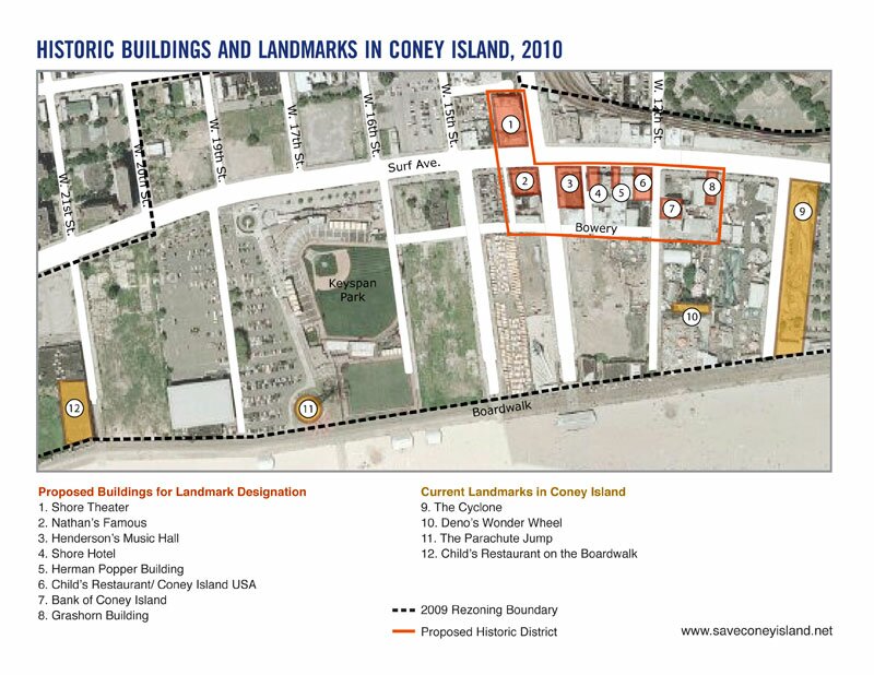
Groups like Coney Island USA and Save Coney Island are advocating for the creation of a small Coney Island Historic District.

Proposed Historic District and Current Landmarks map via Save Coney Island.

The only existing NYC landmarks in Coney Island are: The Parachute Jump, The Cyclone, The Wonder Wheel, and Childs Restaurant on the Boardwalk. And, I must say, I love each of them. Childs is a wonderful, romantic, decaying relic of terracotta in oceanic themes. The Cyclone is still a thrill for kids of all ages, including me.  And, like the Cyclone, the Parachute Jump and the Wonder Wheel are important living memories of summers past for many New Yorkers.

 Childs Restaurant on the Boardwalk, above, and thrills on the Cyclone, below.

Attempts to landmark a few, heavily altered buildings appear to be dead in the water.  These buildings are significant not for architectural integrity but their cultural history.  I have no issues with designating cultural landmarks, and doing so for Shore Theater and Nathan’s Famous (see below) would be a nice olive branch given the scale of development that the city envisions.

The Shore Theater, above, and Nathan's Famous, below.

Landmarking these buildings won't “save” Coney Island. Nor will a small district. In this case, an historic district can only hint at what was once common: a richly varied place full of visual chaos, wild amusements, fanciful entertainment, and cheap thrills.  I say, instead, focus on making Coney Island a rich, diverse, wildly entertaining place for New Yorkers of every stripe.

Surf Avenue Coney Island, c. 1910 Library of Congress , Flickr Commons Project. 

In 2009 the rezoning of Coney Island advanced a new city vision of developer-driven change for Coney Island: one in which hotel and residential towers commingle with neighborhood scale retail, and the amusement areas would be condensed to the area between the ballpark and aquarium. I can understand the concentration of games and rides into one location, and I see the value in making it a more year-round destination. Encouragement new development for Coney Island is also a great goal, though I fear the possibility of homogenization, mediocrity, and privatization of the amusements and amenities. Coney Island is a place for everyone and it should stay that way. (Even if the Cyclone costs $8 for your first ride, the beach is but a subway fare away.)
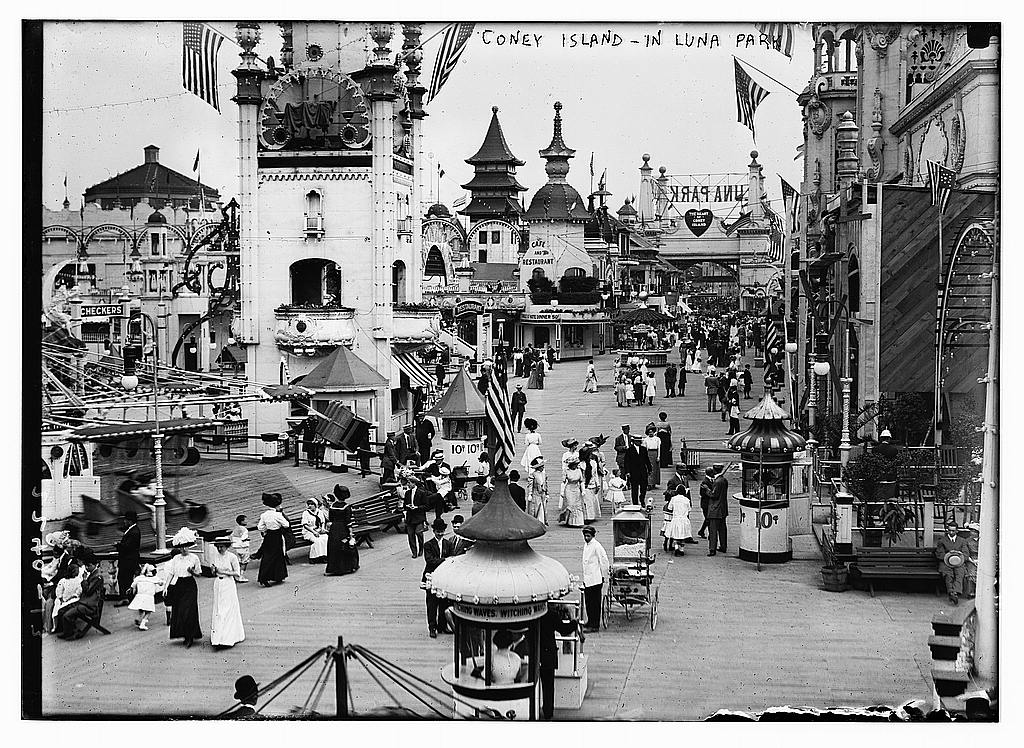
Inside Luna Park, Coney Island, Library of Congress Print and Photograph collection.

Inventive eye-catching attractions and fringe amusements have always characterized Coney Island as New York’s great playground, making it a seaside destination of choice.  Opportunistic developers who used their imaginations made that happen. I would hope that any new development – especially those benefitting from the city’s rezoning or through financial incentives – would keep that in mind.

One feature of Coney Island I feel very strongly about keeping firmly in its place is the boardwalk.  This should be designated as a Scenic Landmark, the same way Eastern and Ocean parkways are.  What would Coney Island (or Brighton Beach) be without its boardwalk? The city should be obligated to maintain it in perpetuity to ensure uninterrupted public access.  Coney Island has had a boardwalk since the 1920s, and it should stay that way.

Coney Island may be a shadow of its former self, but it has good bones.  There’s incredible potential for a renewed Coney Island to demonstrate the values that make New York great: world-class public amenities, imaginative development, and something for everyone.  I don’t see the zoning process or landmarking bringing that about on its own. The large land-holders, like New York City and Thor Equities, need to consider very carefully and think creatively about how to invigorate Coney Island as a richly textured destination. This could be achieved with fine-grained smaller site development, and making space for a large variety of small vendors, kiosks, and games, particularly close to the boardwalk.  It should feel like a bizarre bazaar, not a monolithic or sterile place.

 The Bowery, Coney Island c. 1912, Library of Congress, Print and Photograph Collection.

Coney Island could thrive anew with a density of creative and interesting, amusements and amenities that would attract New Yorkers of every stripe.  There are plenty of vacant lots to build on: start there. Restore Childs on the Boardwalk to anchor an otherwise desolate stretch of boardwalk. Encourage vendors to extend the small shops along the boardwalk to keep it lively and affordable.

Developers, property owners, and the city alike should strive to make Coney Island an adventure, but keep it real.

For More Information check out:
The NYC Department of City Planning's Coney Island rezoning info here.
Coney Island USA's website.
Library of Congress's Sanborn Time Series on Coney Island here.
Library of Congress's Flickr Commons Project Coney Island collection here.


Color photos by Preservator, all rights reserved.

Monday, June 28, 2010

Brooklyn Beach Amusements of the Past

Next up in the Preservator's occasional Palen Postcard series comes a few from the Brooklyn beach amusements of yesteryear. You'll notice that the rides and the atmosphere seem really elaborate, especially by comparison to today's Luna Park, which looks a bit fly-by-night.  

This set is inspired by my trip to Coney Island this past Sunday. I rode the Cyclone and nearly lost my glasses. Twice. It was great. We checked out the local landmarks, and walked the boardwalk. More on Coney Island later, for now the postcards please.


Created with Admarket's flickrSLiDR.

For more Palen Postcard check these: Prospect Park in Postcards

Tuesday, June 15, 2010

Automotive High School

Walking past Automotive High School on Bedford Avenue this past weekend, I was taken by the school's very 1930s message above the door: Manhood Service Labor Citizenship.  What a way to express the virtue of hard work and its contribution to the nation.

The building was built from 1937-1938 after the vocational school outgrew several prior spaces. Though it was once a very versatile vocational school, Automotive High School now focuses on academics as well as automotive education.  They also have a really nice school veggie garden out front. [The New York Times ran this piece about the school in 2007.]

Friday, June 11, 2010

Photo Friday: Fire Escapes

Today's Photo Friday installment is a WPA poster from the Library of Congress "By the People, For the People: Posters from the WPA 1936-1943" collection.I have long loved and browsed this collection, but this one is new to me.

"Keep Your Fire Escapes Clear" dates from April 1937 and was commissioned for the Tenement House Department of the City of New York.

This is the time of year that folks would take to sleeping outside on the fire escape to beat the heat of their apartments.  Hence, perhaps, the mattress among the potted plants up top.  I particularly like someone's white heels outside.

Preservation 101: Know Thy Site

"Know Thy Site" might be one of the first commandments of preservationists and planners. It is, however, one that bears repeating.

I recently listened to a talk by a prominent engineer on the need to do the most basic site research before getting too deeply involved in proposing alterations to historic buildings. His point was largely that design professionals often don't appreciate the early construction methods, prior to building codes and the professionalization of engineering. His rather alarmist perspective was tempered by some basic stuff I think we all know: Do your homework.

Urban construction often has layers and layers of history that is there to uncover, not just in the field but by doing good preliminary sight research.

Consider this example: You're looking at a loft in SoHo, and you thinking, "Right. It's a loft built c. 1890. Done." Not so fast. It's very likely that there's an early 18th century wood frame building inside, due to the early construction methods of creating party walls. Surprise! Because many of these buildings were attached, and keyed into one another, cutting beams was to compromise your neighbor. So when you built up, you built on top of whatever was already there.


See this roof outline along the side of this building on Crosby Street? That's the outline of what might lie inside its still-standing neighbors. By doing some research into current and historic data, you can learn more information that will help you understand the existing structure in question, and inform your in-the-field observations.

Here in NYC it's easier than ever to do research about particular buildings and their sites without leaving your computer. Starting from large scale to small scale:

1. Use OASIS and NYC GIS
Oasis is great for chekcing out historic and present ecological features. Are you working at a site close to the shore that may have once been in the water? Check out the aerial timeline set to see the historical shoreline. NYC GIS has georectified a set of 1924 aerial images. Enter in the site's address and click on the camera icon. Then move the timeline to 1924 to see the site from above in 1924. Slide the timeline back to the present to see how it's changed.

2. Use the Digital Fire Insurance Maps from NYPL to research the site's history. In particular, look at the atlases from the 1850s to start out. Was your site built on? What was it? Use the key and look carefully. Then trace the property forward through time on subsequent maps.

3. Use the Department of Buildings' information system, BIS, to learn any history of permits, "actions" (early violations), and current violations. These can hint at prior work and the types of violations which may still exist. Lots of violations can mean years of neglect or absentee owners.

4. Use the Department of Housing Preservation and Development's website to search for property information by "Complaints, Violations, and Registration Information" to review violations and check the "I-Card", which can often have a floor plan for a multi-family home. This will help you determine if structural members have been moved between the I-Card plan and today's configuration. 

5.  Look up the property's records with the Department of Finance's ACRIS to see ownership patterns.

6. Google! Be a good internet stalker of the past. Look for historic articles from newspapers. Check the Brooklyn Daily Eagle and the New York Times historical databases. You never know, there may be an article about a fire or a write up when the building was constructed.

7. And, of course, if the building is a landmark, read the Landmarks Preservation Commission Designation Report section. 

All of this information can help illuminate clues found in the field and inform what types of interventions will be safe and appropriate in the future.  Happy sleuthing.